Desire to Know
webmaster@desiretoknow.com
Dr. Jane Goodall
webmaster@desiretoknow.com
Global Air Quality
20 Dec, 2015 | Modified 20 Dec, 2015 | Views 2670
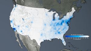
Nitrogen dioxide has decreased from 20 to 50 percent in the United States, and by as much as 50 percent in Western Europe.
New NASA Satellite Maps Show Human Fingerprint on Global Air Quality

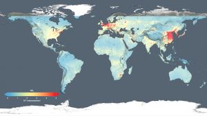
Using new, high-resolution global satellite maps of air quality indicators, NASA scientists tracked air pollution trends over the last decade in various regions and 195 cities around the globe. The findings were presented Monday at the American Geophysical Union meeting in San Francisco and published in the Journal of Geophysical Research.
Duncan and his team examined observations made from 2005 to 2014 by the Dutch-Finnish Ozone Monitoring Instrument aboard NASA's Aura satellite. One of the atmospheric gases the instrument detects is nitrogen dioxide, a yellow-brown gas that is a common emission from cars, power plants and industrial activity. Nitrogen dioxide can quickly transform into ground-level ozone, a major respiratory pollutant in urban smog. Nitrogen dioxide hotspots, used as an indicator of general air quality, occur over most major cities in developed and developing nations.
The science team analyzed year-to-year trends in nitrogen dioxide levels around the world. To look for possible explanations for the trends, the researchers compared the satellite record to information about emission controls regulations, national gross domestic product and urban growth.

The United States and Europe are among the largest emitters of nitrogen dioxide. Both regions also showed the most dramatic reductions between 2005 and 2014. Nitrogen dioxide has decreased from 20 to 50 percent in the United States, and by as much as 50 percent in Western Europe.
China, the world's growing manufacturing hub, saw an increase of 20 to 50 percent in nitrogen dioxide, much of it occurring over the North China Plain. Three major Chinese metropolitan areas -- Beijing, Shanghai, and the Pearl River Delta -- saw nitrogen dioxide reductions of as much as 40 percent.
References
To view and download high-resolution air quality maps, go to: http://svs.gsfc.nasa.gov/12094
For more on NASA’s research into nitrogen dioxide, and air quality data for 195 cities, visit: https://airquality.gsfc.nasa.gov/
NASA
http://www.nasa.gov/press-release/new-nasa-satellite-maps-show-human-fingerprint-on-global-air-quality